Time Imaging vs. Depth Imaging in Subsurface Exploration
Key Takeaways:
- ● Time imaging is a traditional, efficient technique for early-stage exploration but lacks precision in complex geological settings.
- ● Depth imaging offers higher accuracy through iterative velocity modeling, making it essential for detailed subsurface analysis.
- ● The choice between time and depth imaging depends on project needs—speed and cost vs. precision and complexity.
- ● Fairfield Geotechnologies integrates foundational imaging techniques with advanced innovations to enhance subsurface exploration.
In the realm of geophysical exploration, imaging techniques have evolved into critical tools for understanding the Earth’s subsurface. As we explore advanced algorithms in Cenozoic Fill—like Full Waveform Inversion (FWI) and Multiparameter FWI (MPFWI)—and in other critical areas, it is essential to reflect on the foundational practices that laid the groundwork for today’s innovations. Time imaging and depth imaging technology, two cornerstones of seismic data interpretation, represent both the heritage and the ongoing evolution of our field. By mastering these techniques, geoscientists have built a bridge to advanced methodologies that are shaping the future of reservoir characterization and exploration success.
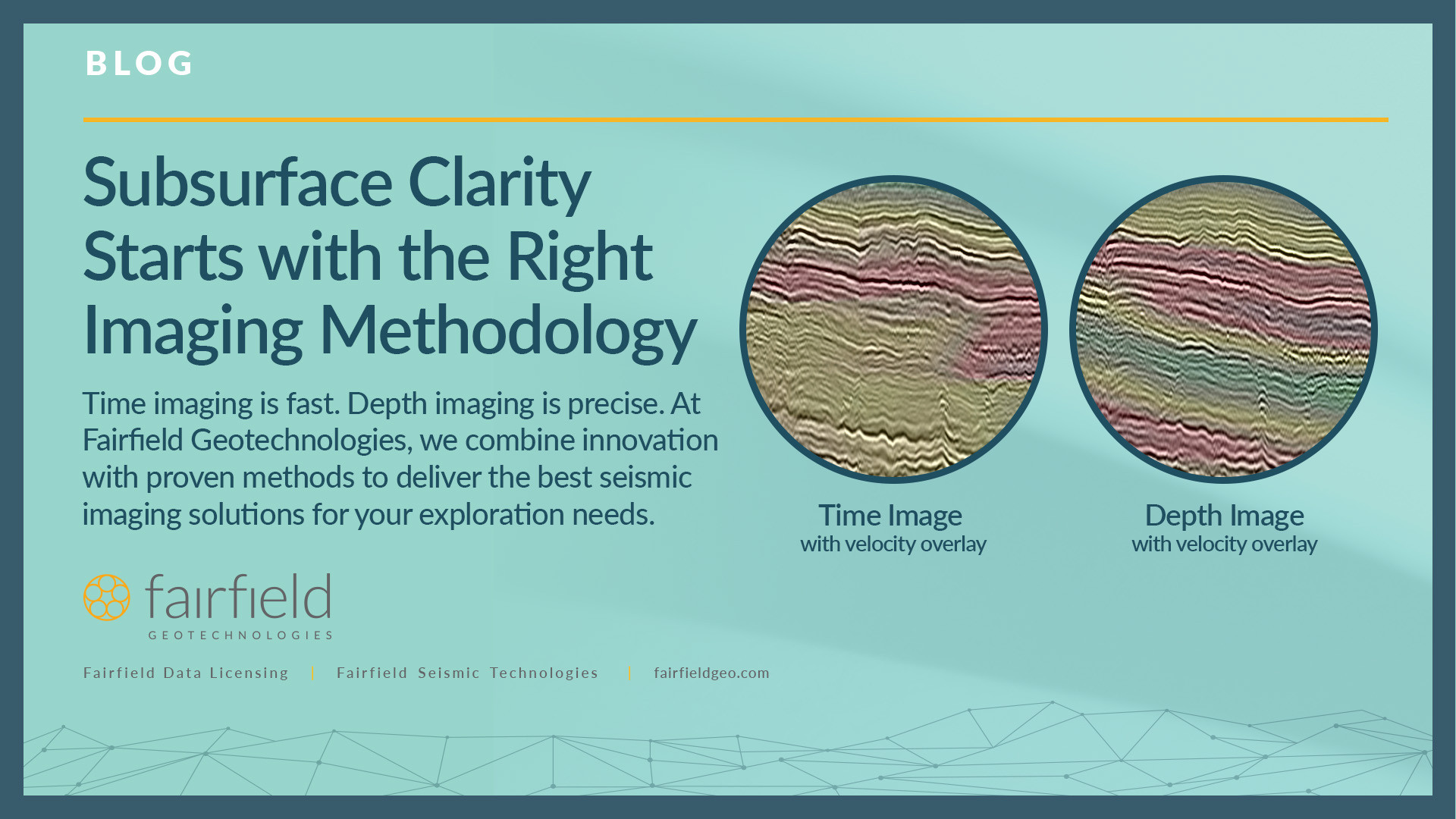
The Basics: What Sets Time Imaging Apart?
Time imaging technology is the more traditional of the two techniques of seismic exploration. Its velocity model is constructed by picking a grid of one-dimensional velocities that are interpolated to create the basis for migration. This approach, while straightforward, has its limitations. The calculated travel times are not as precise, which can lead to imaging challenges in areas of complex geology, such as steep dips, faults, or high-velocity contrasts.
Time imaging works well in settings where the subsurface is relatively uniform and uncomplicated. It is often used in early-stage exploration due to its efficiency and lower computational requirements. However, its simplicity may compromise accuracy in regions requiring detailed seismic wave analysis or geological consistency.
Depth Imaging: A Precision-Driven Approach
Seismic depth imaging takes subsurface exploration to the next level by integrating iterative velocity modeling and migration. Unlike the 1D approach of time imaging, depth imaging employs 3D seismic imaging and velocity models that are continuously refined through depth tomography. This iterative process uses ray tracing through an explicit network grid within the velocity model, leading to more accurate travel-time calculations. The benefits of depth imaging are substantial:
- ● Improved structural integrity and continuity: By accurately accounting for variations in subsurface velocities, depth imaging provides a truer representation of geological formations through reflection seismology.
- ● Enhanced resolution and fault imaging: Seismic depth imaging excels in revealing intricate details, such as subtle faults or stratigraphic traps, making it invaluable in complex thrust belts or low-relief resource plays.
- ● Phase stability and geological consistency: Its precision ensures that phase data remains stable, which is critical for accurate interpretation.
These advantages make seismic depth imaging the preferred choice in complex geological settings, such as areas with steep dips, salt bodies, or intricate fault networks. While computationally intensive, its ability to deliver a more detailed and reliable subsurface image justifies the investment.
Choosing the Right Tool
The choice between time imaging and depth imaging depends on the geological context and project objectives. Time imaging remains an efficient tool for initial explorations, where speed and cost are critical. Depth imaging, on the other hand, is indispensable for advanced stages of exploration and development, where precision can make or break project outcomes. Together, these techniques form a powerful toolkit for geoscientists striving to optimize subsurface imaging and drive successful exploration outcomes.
Looking Forward: Honoring the Past to Shape the Future
At Fairfield Geotechnologies, we believe in leveraging the best of both foundational practices and cutting-edge innovations to advance subsurface seismic imaging technology. As we integrate tools like FWI and MPFWI into our workflows, we never lose sight of the core principles of time and depth imaging that have guided geoscience for decades. By combining these time-tested methods with modern advancements, we empower our clients to navigate the subsurface with clarity, confidence, and precision.
Let us help you visualize the subsurface like never before—because the clearer the image, the greater the opportunity. Contact us today to explore tailored solutions that balance accuracy, efficiency, and cost.
Post Date
Mar 13, 2025Post Category
Technical Papers