Near-Surface Velocity Characterization from Log Scale to 3D Surface-Seismic Scale in the Cenozoic Sedimentary Fill of Eddy County, New Mexico
Stephen Klug, Andrew Lewis, Taylor MacKay, and Bruce Karr (Fairfield Geotechnologies)
Summary
This study investigates the effect of acquisition geometry and near-surface velocity model resolution on seismic imaging in the northern Delaware Basin. The detail within the velocity model is driven by the seismic sampling at the surface. The dense surface seismic data enables FWI algorithms to derive more detailed near-surface velocity models that better resolve evaporite heterogeneity, improve synthetic‑to-seismic correlation, and enhance imaging through shallow geology including the Ochoan-aged evaporites, the Rustler formation, and post-Permian fill sediments.
Introduction
The Delaware Basin is a sub-basin of the greater Permian Basin in west Texas and southeastern New Mexico. In the Delaware Basin there are three major accumulations of the Cenozoic sedimentary fill, more commonly known as “The Fill.” The fill is thought to be caused primarily by the dissolution of halite within the Salado formation causing the overlaying Rustler formation to collapse (Anderson, 1981). The accommodation space generated from the Rustler collapse is then filled in with late Tertiary and early Quaternary sediments (Bachman, 1984). The near-surface complexity caused by the fill dramatically degrades the quality of 2010-2020 vintage 3D seismic surveys at the reservoir level. Much of this degradation is thought to be due to complex ray-pathing that needs to be accounted for during seismic acquisition and processing.
The complexity of the wavefield is related to the near-surface stratigraphy. Interbedded halites and anhydrites create abrupt velocity contrasts within the Castile formation. Above the Castile formation, the varying state of halite dissolution within the Salado formation causes laterally varying velocities depending on the composition of the rock matrix. Where the halite within the Salado formation dissolves, the Rustler collapsed creating structural complexity. Furthermore, where the Rustler collapses, the velocity of the post-Permian fill which contains alluvial sediments within the Gatuna formation is extremely slow. At the surface, the Mescalero caliche overlies the Gatuna formation but is not present throughout the basin.
Near-surface wavefield complexity in the Delaware Basin is a challenge to capture in 3D surface-seismic data. Previous applications have demonstrated that land-based FWI can effectively resolve interbedded halite and anhydrite sequences, which simplifies deeper structural imaging (Bai et al., 2020). This study investigates the role of acquisition geometry and near-surface velocity models to image this complex stratigraphy within the first 4,000 feet of the subsurface in the fill. These near-surface velocity models are then benchmarked on a shallow borehole sonic log acquired within the study area.
Data and Methods
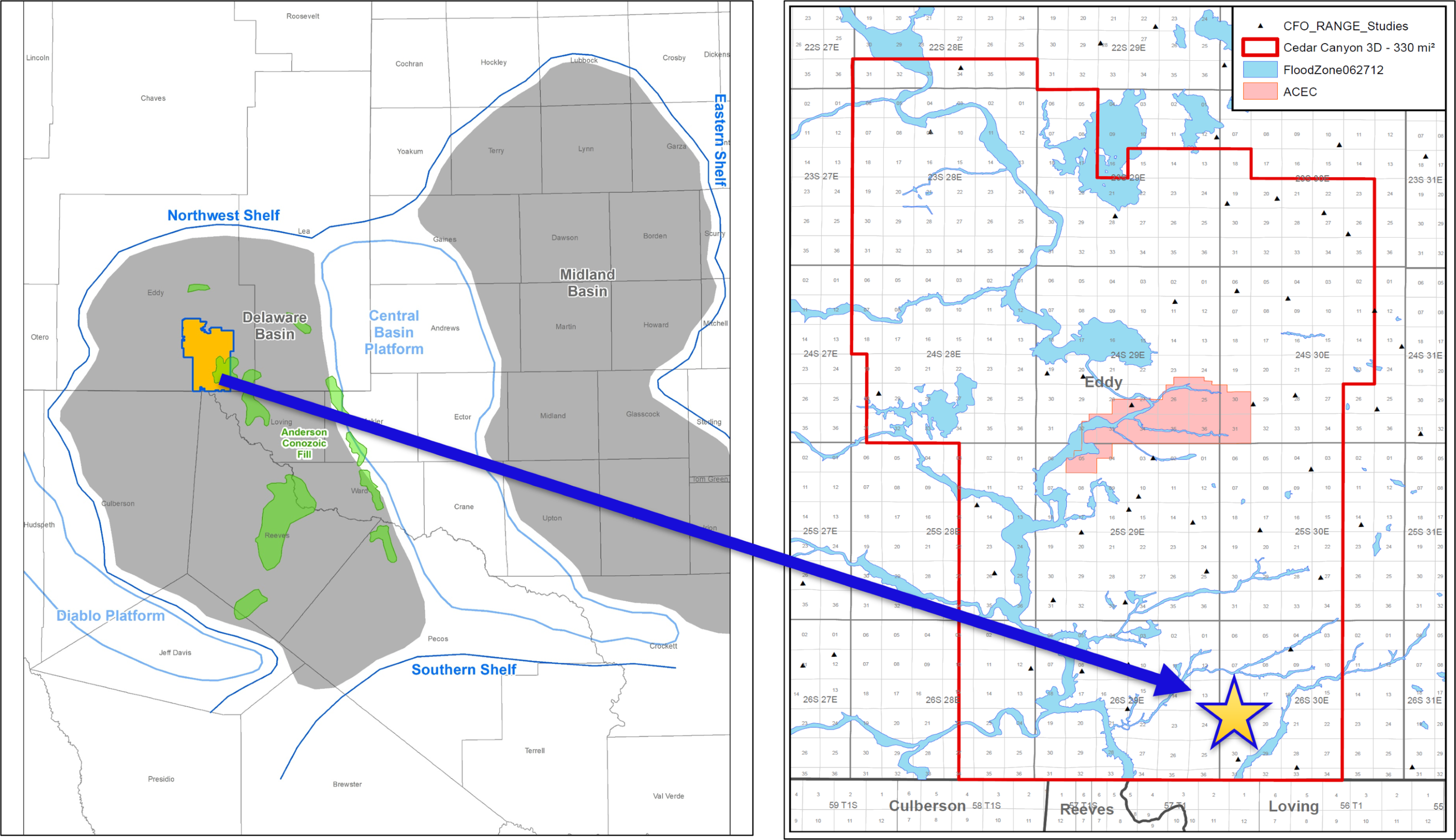
This study presents a comparative analysis of seismic acquisition geometries and imaging workflows to resolve shallow, complex stratigraphy within the Delaware Basin. The seismic data was acquired using a hybrid deployment of Geospace GSR (10 Hz) geophones and Stryde nodes. The GSR geophones consist of a three-geophone array arranged in a triangle deployed at a 495 ft line spacing and 82.5 ft station interval. The Stryde nodes were deployed with a single node per station and utilized a denser configuration of 247.5 ft line spacing and 20.625 ft station intervals. The GSR and Stryde datasets were acquired simultaneously. The source configuration included three vibroseis trucks in a line offset by a tire length each. The source line and station spacings for these surveys were 495 ft and 41.25 ft respectively. The custom sweep deployed at each station was 24 seconds long from 2 – 84 Hz and stayed beneath 10 Hz for the first five seconds. For more details and some base analysis of these datasets refer to Lewis, et al., 2025. A shallow borehole log suite including a sonic log was also acquired as shallow as 200 ft total vertical depth from the Kelly bushing (TVDKB) within the study area (Figure 1.)
The near-surface velocity models derived from three imaging workflows were used as a comparison to the shallow sonic log. A Kirchhoff Pre-Stack Time Migration (KPSTM) and a Kirchhoff Pre-Stack Depth Migration (KPSDM) were applied to the GSR seismic datasaet. The KPSDM processing flow utilized a 17 Hz Time Lag Full Waveform Inversion (TLFWI) velocity model for imaging. The denser Stryde dataset, benefits from the application of FWI Imaging technology using a 40 Hz TLFWI application (Zheng, et al., 2025). To ensure a controlled comparison, pre-processing was mostly consistent across both sensor types, including surface consistent corrections, noise attenuation, demultiple, and 5D interpolation. One significant difference between the processing workflows as it relates to the sensor type is that the GSR dataset benefited from a geophone compensation filter to recover low frequencies while the Stryde dataset simply integrated the acceleration data acquired from the Stryde nodes to the velocity domain for processing and no low frequency compensation was required.
The initial velocity model used for TLFWI is a critical success factor. The creation of the initial velocity model for TLFWI, started by inverting the shallow velocity model above the Castile using first-arrival tomography. Then a deeper background velocity trend was built using borehole sonic logs. The anisotropy parameters were derived through well-tie analysis. This initial velocity model was the same for both the GSR and the Stryde surveys. The GSR survey was used to generate the 17 Hz TLFWI velocity model and its resultant KPSDM, were as the Stryde dataset was used derive the 40 Hz TLFWI model and corresponding KPSDM.
The near-surface velocity models from the respective acquisition and processing combinations are compared to the shallow borehole sonic log data. This provides a qualitative analysis of the detail each velocity model brings to the imaging and how the velocity correlates back to the geology. Furthermore, these logs were used to generate pre-stack synthetic seismograms to compare to the real seismic data. The pre-stack synthetics were generated with a similar mute as was applied to the real seismic data and then stacked for an apples-to-apples comparison of synthetic to seismic stacked traces. The statistical wavelets used to generate these synthetics were generated from the same inline, crossline, and time ranges for consistency. The goal of the synthetic to seismic comparisons was to assess if the differences between the KPSTM, KPSDM + 17 Hz TLFWI, and KPSDM + 40 Hz TLFWI images are in fact real. Then the difference in vertical resolution can be analyzed to understand what combination of acquisition geometry and processing best defines the complex shallow stratigraphy.
Results
Accurate velocity models are critical for achieving reliable subsurface imaging with KPSTM and KPSDM workflows. In structurally complex regions such as the Delaware Basin, rapid lateral and vertical velocity variations driven by near‑surface inversions within the Rustler Formation, Salado halite and associated dissolution zones, thick anhydrite intervals, and stacked halite–anhydrite sequences of the Castile significantly increase migration sensitivity and hinder robust velocity model construction.
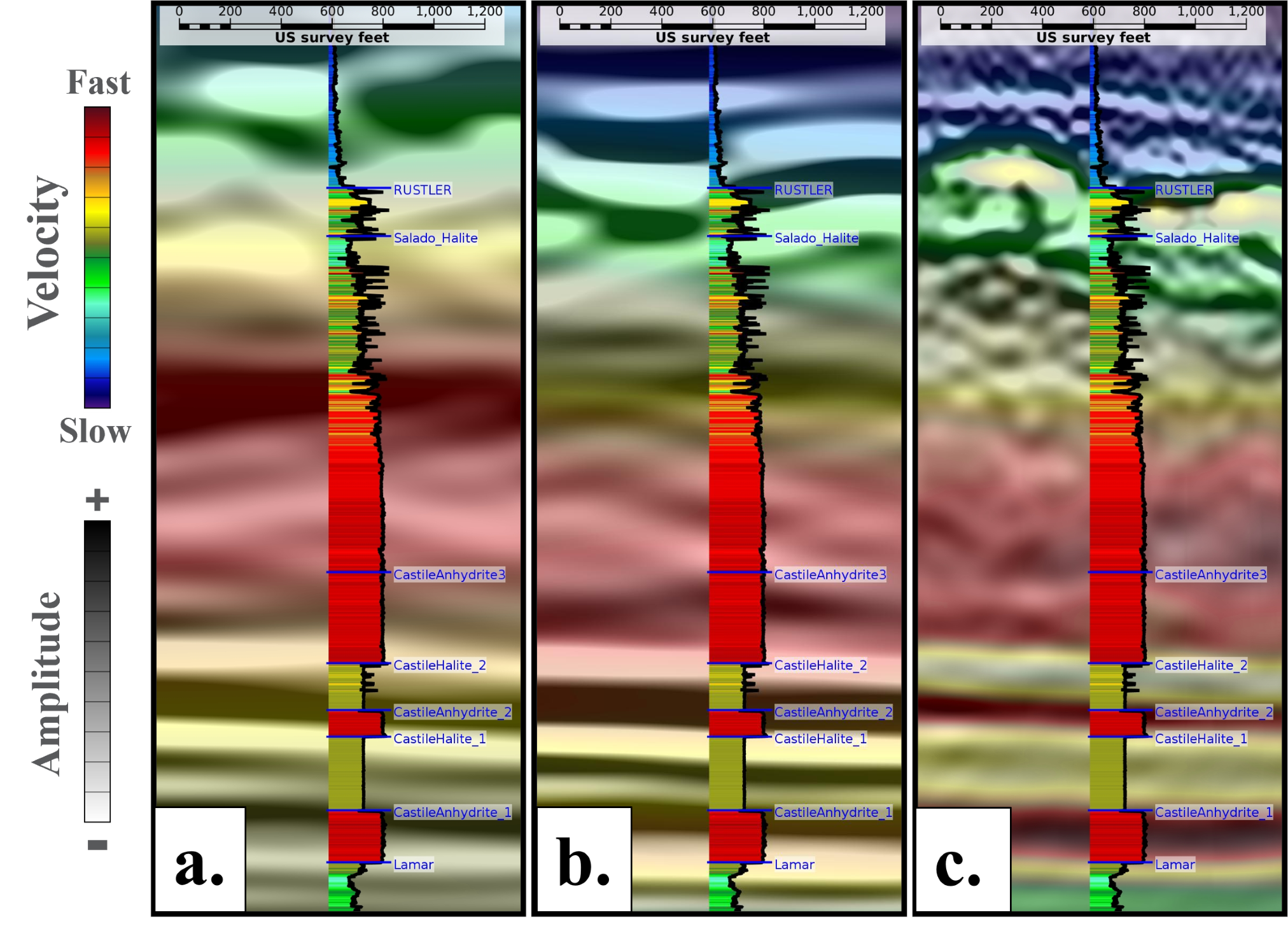
To improve shallow imaging fidelity and better delineate these complex stratigraphic units, TLFWI was applied at 17 Hz and 40 Hz. As illustrated in Figure 2, TLFWI at 40 Hz provides shorter wavelength velocity detail from the Lamar Formation (~4200 ft) upward through the Castile interbedded anhydrite–halite sections (~2500 ft). At the Rustler formation, velocity definition is not as robust as the deeper formations, but there is some evidence that the 40 Hz TLFWI velocity model results significantly improve, in terms of seismic imaging and velocity definition. In all three scenario tests, the 40 Hz results outperforms both the 17 Hz TLFWI and the broader‑wavelength PSTM velocity model.
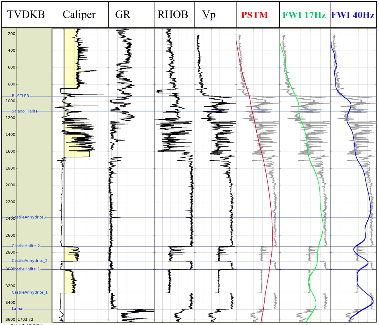
Evaluation of velocity model performance against a reference sonic log (Vp), shown in Figure 3, indicates that KPSTM velocities follow a smoothed background trend, whereas TLFWI models capture higher‑resolution geological variability. Although the 17 Hz and 40 Hz TLFWI velocity models both highly correlate to the thick halite interval between ~1700 ft and 2700 ft. The 40 Hz TLFWI model exhibits superior resolution within the deeper Castile halite–anhydrite sequences where it accurately tracks the anhydrite velocity at about X ft/s and the halite velocity at about X ft/s. These results demonstrate that increasing TLFWI frequency enhances sensitivity to thinner velocity contrasts, enabling more accurate characterization of the complex near‑surface geology.
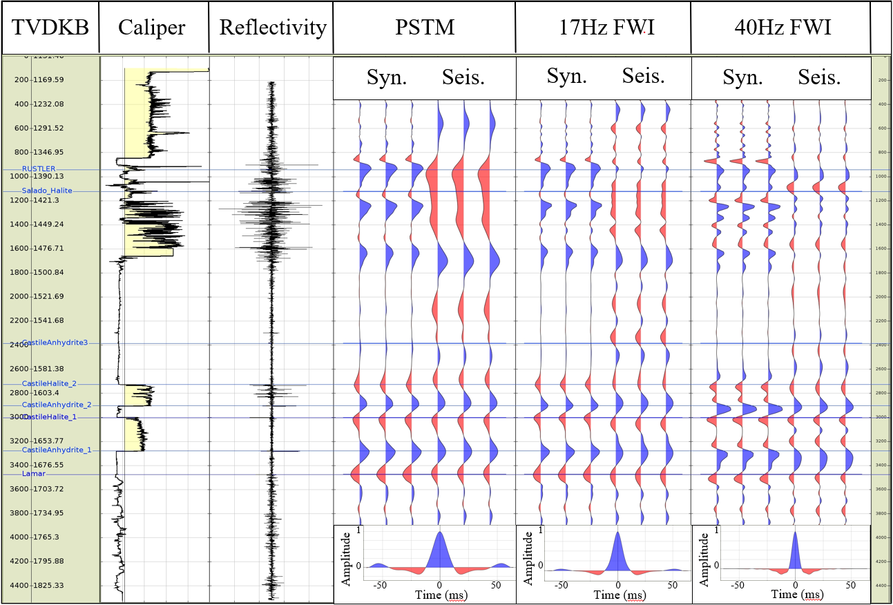
A comparable trend is observed in Figure 4, which evaluates the seismic response at the well location through a combined comparison of stacked seismic data at the borehole location, synthetically generated stacked traces from the borehole logs, and reflectivity profiles extending the assessment beyond velocity only diagnostics. The KPSTM modeled results display a broad, low‑frequency character, indicative of limited sensitivity to the rapid changes in complex geology. The low-frequency statistical wavelet, when convolved with the reflectivity series, becomes constrained in areas with strong impedance contrasts and therefore needs a broader bandwidth to achieve better vertical resolution.
In contrast, the TLFWI derived models capture substantially higher resolution spatial velocity models indicative of the near‑surface geology. The increased frequency range allows the inversion to more accurately reconstruct short‑wavelength velocity variations associated with evaporite heterogeneity, improving the modeled wavefield’s fidelity. This enhancement is most evident within the thick Anhydrite interval from approximately 1700 to 2700 ft, where reflectivity is absent, hence no seismic and synthetic response. Additionally, the 40 Hz TLFWI finer resolution enables clearer delineation of the Castile halite–anhydrite cycles beneath the main Anhydrite section, where layering thicknesses fall near or below the tuning limit of the lower‑frequency KPSTM model and perhaps 17 Hz TLFWI.
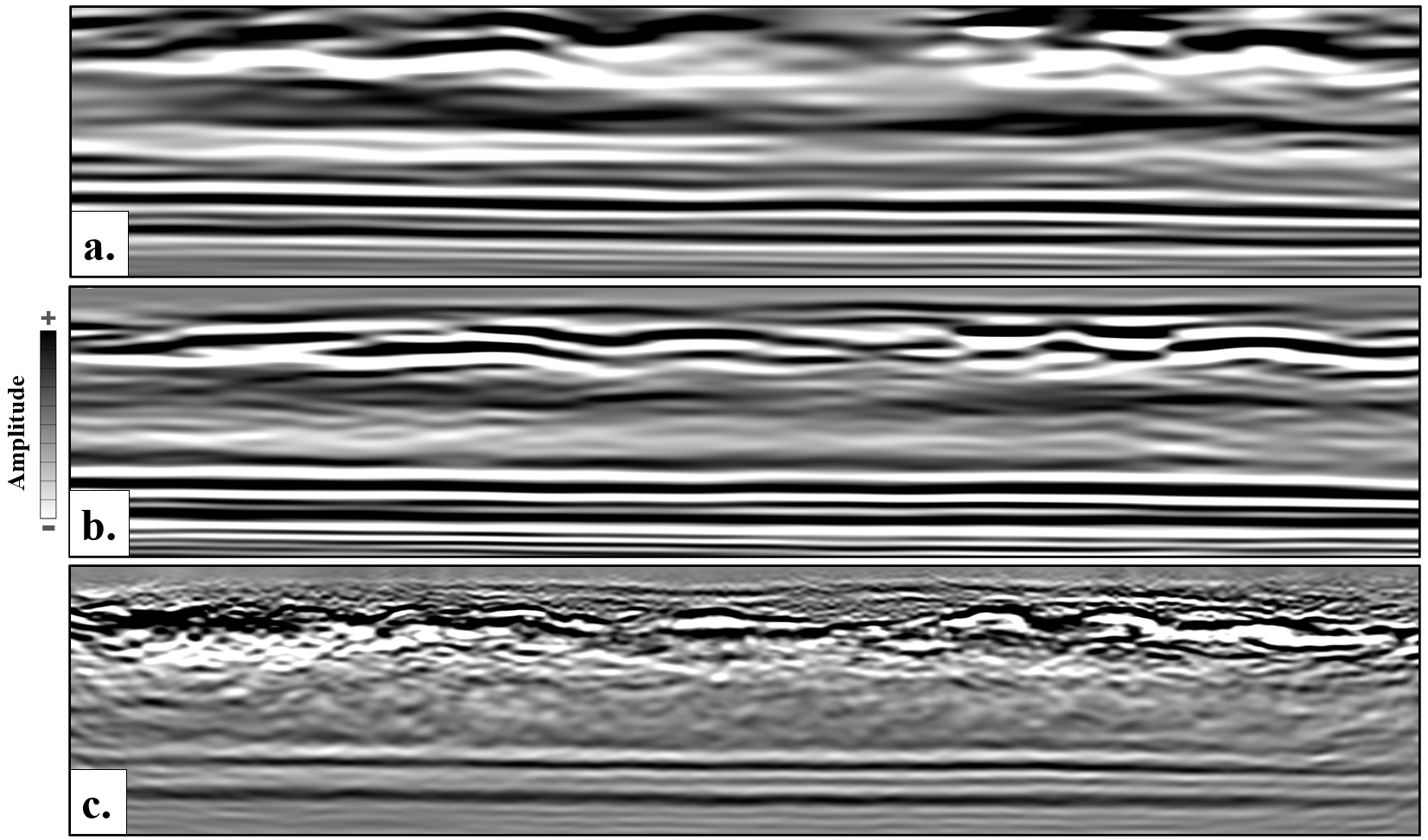
In shallow formations, velocity estimation becomes increasingly challenging due to structural complexity associated with Salado dissolution and the collapse of the Rustler Formation. These effects are compounded by well‑log uncertainties, including Vp, Vs, and density inaccuracies related to poor tool coupling indicated by caliper log from about 400 – 1700 ft. This makes the synthetic to seismic comparisons at the Rustler formation more difficult to assess. Despite these limitations, the 40 Hz TLFWI model provides the most reliable near-surface characterization, outperforming both the KPSTM and the 17 Hz TLFWI models. Within the Rustler and Salado formations, from 800 to 1,600 ft, the 40 Hz velocity model shows better agreement with the sonic log and seismic stack, as illustrated in Figures 2 and 3. Furthermore, the overall KPSDM 40 Hz stack in Figure 5 demonstrates superior vertical resolution and captures the short-wavelength velocity variations essential for resolving the complex stratigraphy.
Comparisons of migrated stacks (Figure 5) demonstrate progressive improvements in structural imaging as velocity model frequency increases from KPSTM to 17 Hz and ultimately to 40 Hz TLFWI. These enhancements reflect both the benefits of higher‑frequency velocity content and the contribution of dense acquisition, which supports more detailed velocity recovery at depth. In Figure 5c. the resulting images more clearly delineate the Rustler Formation, reveal initial indications of Salado features, and produce higher‑resolution images of the Castile anhydrite and halite sequences. These results highlight the importance of short‑wavelength velocity solutions, derived by both acquisition design and higher frequency full‑waveform inversion. Inherently pulling out the individual geological layers in high complex near surface geology setting within the Delaware Basin.
Conclusions
The Delaware Basin contains a highly heterogeneous near‑surface geological environment, characterized by dissolution within the Salado Formation, collapse of the Rustler Formation, and the Castile halite–anhydrite cycles beneath a thick anhydrite section. These complexities create strong lateral velocity variations that challenge conventional seismic imaging. This study evaluates how velocity model fidelity influences imaging quality by comparing PSTM, 17 Hz TLFWI KPSDM, and 40 Hz TLFWI KPSDM workflows acquired using two distinct acquisition systems: GSR geophones and densely sampled Stryde nodes. Benchmarking against borehole sonic data shows that KPSTM velocities capture only broad trends, whereas both the 17 Hz and 40 Hz TLFWI velocity models resolve detailed interbedded anhydrite–halite sequences and dissolution‑related heterogeneity. Moreover, the higher‑frequency 40 Hz TLFWI model provides the most geologically consistent velocity field, improving vertical resolution and enhancing seismic reflection character and geological detail across the Rustler, Salado, and Castile intervals.
This study did not evaluate the impact of acquisition density versus higher frequency TLFWI. A valuable future investigation would compare dense acquisition using lower frequency TLFWI with higher frequency TLFWI, while keeping the acquisition line and station spacing consistent.
Additionally, further analysis is recommended to better quantify reservoir level effects and assess the impact of higher frequency TLFWI cascaded with lower-frequency TLFWI below the Lamar Formation. This approach would help clarify how improved near-surface imaging influences the seismic response at reservoir depths, particularly within the interbedded shale–sand sequences of the Bone Spring and Wolfcamp formations.
Acknowledgements
Special thanks to Fairfield Geotechnologies along with Devon, Oxy, ConocoPhillips and Chevron for permission to publish this work. Our sincere gratitude to the Viridien team who worked diligently on processing and imaging of these data.
References
Anderson, R. Y., 1981, Deep-seated salt dissolution in the Delaware Basin, Texas and New Mexico: Environmental geology and hydrology in New Mexico: New Mexico Geological Society Special Publication, 10. pp. 133-145.
Bachman, G. O., 1984, Regional geology of Ochoan evaporites, northern part of Delaware Basin: New Mexico Bureau of Mines and Mineral Resources, Circular 184, 22 pp
https://doi.org/10.58799/C-184
Lewis, A., Karr, B., Klug., 2025, Receiver Type and Receiver Station Spacing Comparisons from an Acquisition Test in Eddy County, New Mexico. First EAGE Workshop on Land Seismic Acquisition 8-9 May 2025, Calgary, Canada. Presented at EAGE Canada, 2025
https://doi.org/10.3997/2214-4609.202580002
Bai, D., Zheng, L., Deng, W., 2021. Imaging the complex geology in the Central Basin Platform with Land FWI.
https://doi.org/10.1190/segam2021-3583769.1
Zheng, L., Hou, F., Sun, S., 2025, Imaging the Delaware Fill Zone with ultra high-density data and high-frequency land FWI
Presented at IMAGE, 2025.
Post Date
Aug 18, 2026Post Category
Technical Papers